
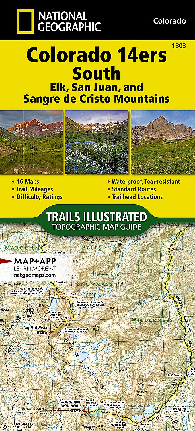
Colorado 14ers South [San Juan, Elk, and Sangre de Cristo Mountains] (National Geographic Topographic Map Guide, 1303)
$14.95
Price: $14.95
(as of Mar 24,2022 22:48:49 UTC – Details)

From the Publisher
Conquer the Rockies with National Geographic’s Colorado 14ers Topographic Map Guide Booklets

The Most Authoritative and Usable 14er Maps
The Map Pack includes authoritative and beautifully designed trail maps for all 58 of Colorado’s peaks over 14,000 feet in a single two-booklet bundle. Each map page provides accurate trail statistics including trail mileages, total elevation gain and loss, elevations at trail junctions, and trailhead elevations and directions to trailheads. Route information includes climbing class (i.e. difficulty rating) and points of reference along the route. The maps include both 2WD and 4WD trailhead locations for the standard, recommended summit route.
More convenient and easier to use than folded maps, but just as compact and lightweight, National Geographic’s Topographic Map Guide booklets are printed on ‘Backcountry Tough’ waterproof, tear-resistant paper with stainless steel staples.

All 58 Fourteeners in Two Compact Booklets
Colorado 14ers North includes the fourteeners of the Front, Mosquito, Tenmile, and Sawatch ranges. Almost half of Colorado’s fourteeners fall in these ranges, but their proximity to large population centers leave no shortage of hikers on their slopes. Moderate ridges, established trails, and accessible trailheads are the norm on the standard routes, making many (but not all) of these peaks relatively easy to climb.
Colorado 14ers South includes the fourteeners of the Elk, San Juan, and Sangre de Cristo ranges. These peaks are generally more difficult than their northern counterparts. Even the easier ones like Humboldt, Sunshine, Redcloud, and Handies have their unforgiving slopes. Crestone and Little Bear in the Sangres and Capitol Peak and Maroon Bells in the Elk Range, are among the “hardest” fourteeners.
Technical Specs
Map Scale = 1:40,680 & 1:63,360
Folded Size = 4.25″ x 9.38″
Waterproof, tear-resistant paper
Full UTM grid to aid GPS navigation
Trail segment mileages
Elevations at trailheads and junctions
2WD and 4WD trailhead locations and directions
Get the Intel You Need to Bag all of Colorado’s 14ers Efficiently, Enjoyably, and Safely


Save with the Bundle!
Save 15% when you buy the Map Pack Bundle. We’ve put the Colorado 14ers North and South Trails Illustrated map booklets together in a convenient bundle product to make it easier and more affordable for you to get the intel you need to bag all of Colorado’s majestic 14ers.
Find the Best Views and Campsites
The maps include campgrounds and public land boundaries, along with points of interest and detailed notes to keep you safe and informed. They also include rules, regulations, and guidelines for visiting and preserving the National Parks and Monuments, National Forests, Bureau of Land Management (BLM) and other public lands.
20 Years of Trail-Tested Maps
With more than 250 titles available for America’s favorite outdoor destinations, Trails Illustrated maps are the most trusted and popular recreation maps available. Continually setting the standard for accuracy, each map is crafted in conjunction with local land managers and undergoes rigorous review and enhancement.
Plan Your Climbs With the Most Authoritative and Easy to Use Maps and Stats

None of Colorado’s 14ers are a cakewalk, but some are more challenging and technical than others. Use the classification tables to compare mountains and plan and execute your climbs safely and efficiently.


Colorado 14ers South
ELK MOUNTAINS: Capitol Peak, Castle Peak, Conundrum Peak, Maroon Peak, North Maroon Peak, Pyramid Peak, Snowmass Mountain; SAN JUAN MOUNTAINS: El Diente Peak, Mount Eolus, North Eolus, Handies Peak, Redcloud Peak, San Luis Peak, Mount Sneffels, Sunlight Peak, Sunshine Peak, Uncompahgre Peak, Wetterhorn Peak, Mount Wilson, Wilson Peak, Windom Peak; SANGRE DE CRISTO MTNS: Blanca Peak, Challenger Point, Crestone Needle, Crestone Peak, Culebra Peak, Ellingwood Point, Humboldt Peak, Kit Carson Peak, Mount Lindsey, Little Bear Peak
Colorado 14ers North
FRONT RANGE: Mount Bierstadt, Mount Evans, Grays Peak, Longs Peak, Pikes Peak, Torreys Peak; MOSQUITO, TENMILE RANGES: Mount Bross, Mount Cameron, Mount Democrat, Mount Lincoln, Quandary Peak, Mount Sherman; SAWATCH RANGE: Mount Antero, Mount Belford, Mount Columbia, Mount Elbert, Mount Harvard, Mt of the Holy Cross, Huron Peak, La Plata Peak, Mount Massive, Missouri Mountain, Mount Oxford, Mount Princeton, Mount Shavano, Tabeguache Peak, Mount Yale
Bag Two 14ers in One Day!
A Colorado fourteener is any mountain in the state whose summit exceeds 14,000 feet in elevation. There are five unofficial fourteeners: Conundrum Peak, El Diente Peak, Mount Cameron, North Eolus, and North Maroon Peak. Although all have summits above 14,000 feet, they are considered unofficial because their peaks do not rise 300 feet above the saddle that connects them to a higher peak. The maps show you where to follow the connecting ridges to summit two 14ers in one day.
Publisher : National Geographic Maps; 2019th edition (January 1, 2019)
Language : English
Map : 44 pages
ISBN-10 : 1566957001
ISBN-13 : 978-1566957007
Item Weight : 4 ounces
Dimensions : 4.1 x 0.3 x 9.2 inches
Related Products


$14.95
